


March 14, 2014
Livable Communities and Water Fact Sheet
The compact, mixed-use, walkable development that is encouraged by the Livable Communities / Smart Growth movement turns out to be a perfect fit when it comes to planning for future water supplies. This fact sheet explains for elected officials the surprising links between livable communities and water – and the many benefits of acting on them.
Correction: In the “Economic Implications” section of this fact sheet, National Pollutant Discharge Elimination System (NPDES) was incorrectly referred to as Non-Point Discharge Elimination System. This has been corrected.
Download PDF: Livable Communities and Water
Livable Communities and Water
Key facts about growth and California’s water supplies
“The biggest influence on future water supplies and water quality in California is local land use planning.”
Celeste Cantú
Executive Director, California State Water Resources Control Board
California will add 18 million new residents over the next 15 years.
To supply affordable water to this growing population, we must preserve existing local supplies of water and keep them free of pollution.
According to the U.S. EPA and the California State Water Resources Control Board, the greatest single threat to local water supplies is growth. Local government decisions about where we grow and how we grow are critical to California’s future water supplies.
How Not to Grow
Growth: More Miles than People
Most current land use practices support auto use, at the expense of pedestrians and transit. As a result,
between 1970 and 1996, the U.S. population grew by 30% but the miles traveled by car grew by 123%.
Auto-oriented land-use patterns are the major cause of water pollution.
Roughly 65% of our nation’s impervious surfaces is for use by cars (parking, driveways, roads), while only 35% of the total is for structures – such as houses, stores and patios.
Cars deposit heavy metals (such as copper, iron and cadmium), oil, grease and gasoline on roads and parking lots, which are then carried to streams, rivers, lakes and oceans during periods of rain. Urban runoff is responsible for well over half of the nation’s water pollution. The air pollution created by cars also contributes to pollution of water supplies.
Auto-oriented land-use patterns contribute to flooding.
Impervious surfaces – made up mostly of roads and parking lots – prevent water from filtering through
the soil, and increase urban runoff.
A one-acre parking lot, for example, produces about 16 times the volume of runoff that comes from a one-acre meadow. The meadow absorbs the water that falls on it, replenishing underground water supplies. The parking lot allows the water to runoff – into local waterways, contributing to pollution and flooding.
One study demonstrated that compact, walkable development can reduce runoff by two-thirds compared to sprawl development.
Where and How to Grow
Where: In Already Disturbed Areas
To maintain existing local supplies of water, growth in important watersheds needs to be avoided.
Watersheds are the source of precious local water supplies. They also provide flood protection, improve water quality, and allow groundwater recharge.
According to a recent report by the World Wildlife Fund and the World Bank, protecting watersheds is no longer a luxury, it is a necessity. “When they are gone, the costs of providing clean and safe drinking water to urban areas will increase dramatically.”
To preserve local water supplies, California’s growth will best be accommodated in already developed areas, to the maximum extent feasible.
How: Walking Beats Driving
For the sake of preserving our water supplies, we need to grow in the form of compact, mixed-use, transit-oriented development.
Doing so will provide alternatives to driving and the water-related problems associated with cars.
According to the U.S. EPA, more compact, walkable, mixed-use and transit-oriented land-use patterns can reduce the number of miles traveled by car 15% to 52% and reduce the associated toxic by-products.
Sonoma County’s Sales Tax Protects Open Space
In 1990, Sonoma County residents voted to create the Sonoma County Agricultural Preservation and Open Space District which has used funds raised from a local sales tax to acquire, or protect from development, more than 58,000acres of land. At the same time, cities in the county are focusing on city-centered growth.
Pasadena Plans for Walkable Development around Transit Stops
In 1993, the City of Pasadena, CA, adopted a general plan that designated where new growth should occur. The plan targeted new development around transit stops. Since then, city officials have worked with community residents to develop specific plans for these areas. The specific plans specify compact, mixed-use, walkable development.
More than 85% of all permits for new housing issued by the City after the plan’s adoption have been in Pasadena’s Central District and have been located near transit.
Hercules’ Code Creates Attractive Compact Center
In 2001, the City of Hercules, CA, adopted a “Regulating Code” intended to foster compact, walkable, mixed-use development in a newly created town center. The Hercules code covers four districts in the central part of town.
It specifies street type and streetscape features, along with facade details and architectural standards, consistent with form-based codes’ emphasis on building form and the public realm. Since its adoption, development has flourished in the area covered by the code.
Environmental Impacts
Cars and Water Quality
Compact, walkable communities reduce vehicle miles traveled. Reducing auto travel reduces
the toxic auto by-products that are washed off roads and into waterways during heavy rains.
Cars and Air Quality
The very same walkable community design that preserves water supplies and reduces water pollution also reduces air pollution and the gases that contribute to water pollution and global warming.
Open Space and Water Quality
Saving open space preserves water resources. Numerous studies show that, by virtually very measure of ecosystem health, the streams, creeks, marshes and rivers in watersheds where over 10% of the land has been paved over show clear signs of degradation.
Where more than 25% of the watershed is covered with impervious surface, streams can no longer support a diverse ecological community.
Compact Development and Water Quality
A recent U.S. EPA report concludes that accommodating new growth in a compact, high-density fashion
protects water quality. Compact development reduces impervious surfaces and makes it easier to protect more natural areas, which are the most important steps a community can take to maintain water quality.
Economic Implications
Infrastructure Costs
The infrastructure of compact, walkable development costs less to build and maintain than the sprawl pattern of extending infrastructure to undeveloped areas. The costs of water service infrastructure are important to local government since they bear the bulk of these costs.
Studies show water and sewer costs are about 40% higher in spread-out development than in compact development.
Water Treatment Costs
A study of 27 diverse watershed types revealed that in areas where less than 40% of the land in a watershed was developed, the treatment cost of water per million gallons was about $30. Where the land was completely paved over or dedicated to intensive agriculture, the cost to supply drinking water to the community was $140 per million gallons.
Regulatory Costs
Compact development and reduced impervious surfaces are considered best management practices that can be used to meet stricter Phase I and II National Pollutant Discharge Elimination System (NPDES) permit requirements. These best practices will be less expensive than conventional systems that will also need further treatment.
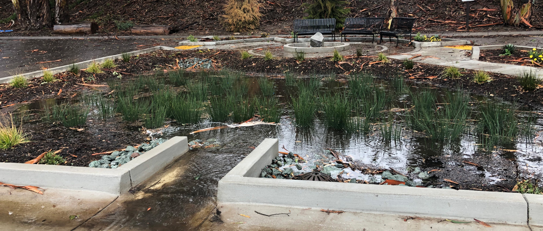
For example, the estimated cost for handling the stormwater at the new Inland Empire Utilities Agency headquarters building in Chino, CA, with a concrete-box channel, curb and gutter, landscaping and conventional storm drains was $3.24 million.
With an innovative design that employed bio-swales, bio-strips, roof drains, proper vegetation and irrigation, detention ponds and permeable surfaces, the completed cost was $1.83 million – a 44% savings.
Property Values
Investors expect real estate values over the next 25 years will rise fastest in communities that have a “pedestrian-friendly configuration.” This means higher property taxes for those communities that grow in a pedestrian-friendly way.
New York City’s Conservation Easements Curb Costs
Recognizing the importance of intact natural areas to the amount and quality of water resources, New York City purchased land and conservation easements in upstream watersheds to protect the City’s drinking water supplies. New York’s Department of Environmental Protection invested $1.5 billion acquiring the land instead of spending $8 billion on a new water treatment system.
What Local Government Can Do
Insert the Ahwahnee Principles for Resource-Efficient Communities in the Land Use Element of the General Plan.
CivicWell’s Ahwahnee Principles for Resource-Efficient Communities prescribe compact, walkable development. Hundreds of local jurisdictions have already adopted these principles, in whole or in part. The League of California Cities and the California State Association of Counties have adopted similar model land use policies.
Reform zoning codes to allow and encourage compact, walkable development.
Because they are based on density and use, most local zoning codes make compact, mixed-use, walkable development illegal.
Adopting form-based codes can overcome this problem. Form-based codes place a primary emphasis on building type, dimensions, parking location, and facade features, and less emphasis on uses. They stress the appearance of the streetscape, or public realm, over long lists of different use types and densities. They also assist developers by making it clear what the community wants, thereby shortening the approval process.
Speed up the development process for developers who propose compact, walkable development.
The cost to developers of holding land while they go through the arduous process of gaining entitlements is enormous. Developers say the most effective incentive for changing development patterns is a clear and simple process that will save them time.
Evaluate site plans with an eye to minimizing both impervious areas and disruption to natural drainage and vegetation.
Create a funding source for purchasing and protecting valuable open space areas.
Suggested Language for General Plans
Community design should be compact, mixed use, walkable, and transit-oriented so that automobile-generated urban runoff pollutants are minimized and the open lands that absorb water are preserved to the maximum extent possible.
– Ahwahnee Water Principle #1