


January 19, 2013
For decades wide suburban-style streets have been the norm in new developments. As the Smart Growth movement gained momentum, emergency response agencies, especially fire departments, expressed concern about the narrower streets seen in many Smart Growth developments. Their fears were that these streets would slow down responding vehicles in an emergency situation where seconds are precious, not provide sufficient setup room for fire trucks with ladders and “outrigger” stabilizer legs, and not allow second or third vehicles on a scene to pass a deployed fire truck.
CivicWell (formerly the Local Government Commission) prepared two fact sheets that address these issues, summarizing the solutions that make safe Smart Growth streets work for emergency responders as well as residents. The first fact sheet “Traffic Calming and Emergency Response“ discusses retrofit solutions and the second, “Street Design and Emergency Response” looks at initial street design.
These fact sheets are part of a larger project funded by the U.S. Environmental Protection Agency to explore trends in emergency response activities, fire vehicle types, and model fire codes. As part of this project, CivicWell and Dan Burden of Walkable Communities, Inc., have conducted workshops in Northern and Southern California with planners, engineers, and fire officials. These sessions have discussed the hazards represented by excessive street width, and present design solutions that produce narrower streets that are safer for drivers and pedestrians alike.
Development of this publication was funded by the U.S. Environmental Protection Agency.
Traffic Calming and Emergency Response
Traffic calming and what it can do
Traffic calming is a general term for redesigning or retrofitting existing streets to slow vehicle speeds. Traffic calming measures improve safety and convenience for pedestrians and bicyclists, and often motorists as well. It is worth noting that most of these techniques provide other things that improve the “feel” and livability of a street, such as wider sidewalks, bike lanes, curbside parking, and landscaping. In numerous cases nationwide, the street that was created by a traffic calming project so improved the feel of the area that it triggered a social and economic revitalization. The worse the existing situation, the greater the potential for this positive impact.
Traffic calming on the rise
Two factors have led to a surge in traffic calming projects. Residents often turn to traffic calming to respond to increased traffic and high vehicle speeds in their neighborhoods. Also, each successful project becomes a visible signal of the potential for improvement, leading to additional requests.
Possible conflicts between traffic calming and emergency response
There is no denying that poorly thought-out traffic calming projects have created headaches for emergency responders. This is because the two tools most commonly provided when neighborhoods complain about traffic speeds – speed humps and stop signs – have the potential to increase response times, and can be hard on equipment.
Resources for finding solutions
This fact sheet and other CivicWell materials suggest a more careful approach in which emergency responders participate with residents and local jurisdictions to develop programs that minimize impacts on response times.
Traffic Calming Techniques
A few common traffic calming tools are summarized here. More detailed information about these and other techniques can be found in Streets and Sidewalks, People and Cars. This guidebook discusses the proper use, benefits, costs and considerations of each technique.
Speed Humps
This device, which forces drivers to slow down by adding a bump or vertical deflection to the road, is often the most used tool since it is widely known and is relatively inexpensive. However, it is often used inappropriately where other measures might work better. Speed humps and tables may slow most vehicles, but not trucks or SUVs, and they can also produce speed spikes. They are best used when narrow streets don’t provide room for better and more aesthetic measures. Because speed humps can slow down emergency responders by 6 to 11 seconds, they should not be deployed on primary response routes.
Roadway Narrowing
This technique slows vehicle speeds by visually or physically narrowing the driver’s “turf” on the street. This can be as simple as striping for bicycle lanes, or as comprehensive as a complete makeover of the streetscape with landscaping, wider sidewalks, bike lanes, and reduced numbers of vehicle lanes. Improperly designed narrowing projects can create problems if they leave insufficient room for drivers to pull out of the way of emergency vehicles, or introduce long medians which prevent emergency vehicles from crossing into oncoming traffic lanes to get through signalized intersections.
Bulbouts or Curb Extensions
This measure targets pedestrian crossings at corners or mid-block. It reduces the width of the crossing and also reduces vehicle speeds, which both improve safety for people on foot. It also directs pedestrians to marked crossings, which can be visually enhanced with landscaping.
Roundabouts
This device is a raised, preferably landscaped center island in an intersection, with triangular deflector islands on each approaching street. Mini circles are installed without the deflector islands on each approaching street. The deflection path for vehicles entering and exiting the roundabout insures that speeds are kept below 20 mph. Pedestrian crossings are moved slightly away from the roundabout, using the deflector islands. Mini circles are installed without the deflector islands at smaller intersections, and best used on quieter residential streets. These tools that rely on vehicles yielding can greatly improve safety for all parties, and efficiently handle large traffic volumes at formerly signalized intersections.
Pedestrian Refuge Islands
This device can be used at intersections or mid-block pedestrian crossings. It provides a place for a pedestrian to stand safely in the middle of a two-way street until a gap in traffic appears. Refuge islands are most useful where high vehicle volumes and speeds exist. Like bulbouts, pedestrian refuges improve safety at crosswalks, and slow vehicle traffic.
Goals
The overriding goal of traffic calming should be to improve pedestrian and bicycle safety without severely limiting vehicle travel or significantly affecting emergency response. The objective is not to block vehicle traffic, but to slow it down and keep it flowing more smoothly, especially through intersections. Although stop signs and signals are often requested to address speeding, it is important to understand that they are not traffic calming techniques. Observations reveal that stop controls cause a phenomenon called “speed spiking” as drivers accelerate to higher speeds between stop signs to make up for perceived lost time. This exacerbates the problem. Many drivers will also roll through unjustified stop signs, introducing a new hazard to pedestrians and other vehicles. Traffic calming can also improve the streetscape, provide landscaping and add parking. It is also critical to develop traffic calming measures that don’t impede emergency response times. However, concern for this public safety issue must be tempered with a recognition that busy, chaotic streets create safety hazards for pedestrians, drivers, and bicyclists on a daily basis.

Focus on solutions with minimal impacts on emergency response
- Never view traffic calming as a piecemeal response to each successive complaint. It should always be comprehensive, considering the safety issues and solutions throughout a neighborhood or corridor.
- Engineers and decision-makers must avoid the often automatic response of throwing a stop sign or speed bump at a safety problem. These measures can be counterproductive, and impede emergency response.
- Traffic calming programs must always include all affected parties, including residents, emergency responders and non-motorized users of the street.
- Emergency responders must understand that wide and open streets that facilitate emergency response can also be counterproductive – wide streets are themselves a source of danger to pedestrians and bicyclists. Traffic calming should never develop into a “residents against the firefighters” situation. The two safety perspectives are not irreconcilable. Focus on techniques that meet the needs of all users to improve safety and livability.
- Traffic calming requires an understanding of the dynamics of driver behavior, pedestrian and bicycle activity, and emergency response needs.This requires thinking that goes beyond traffic and emergency response manuals. Any traffic calming program that does not fully embrace this broader perspective is doomed to failure.
Street Design and Emergency Response
When your community considers the use of traffic calming measures to add safety and pedestrian features to existing streets, smart-growth street design approaches should be structured to get things right in the first place. This fact sheet, which summarizes good street design strategies and tools, is intended for emergency response officials involved in reviewing new developments that are different from conventional, post-war suburban designs.
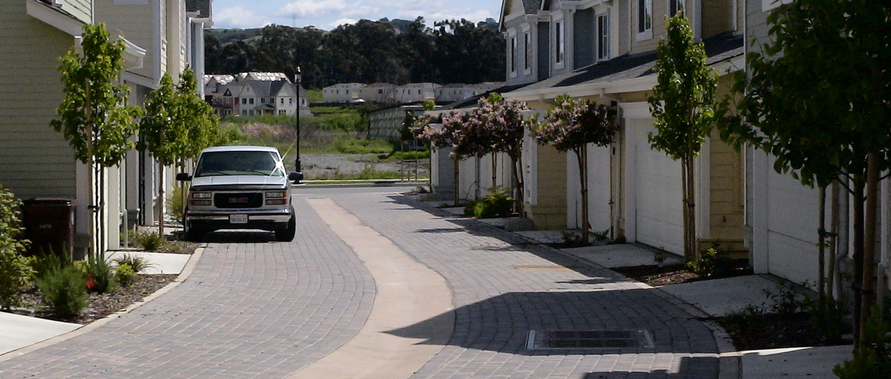
This is not uncharted territory. In a sense, smart growth is about going back to street designs that were once the norm. Typical street designs from colonial times to World War II featured short blocks, few dead-end or cul-de-sac streets, pavement as narrow as 20 feet, vertical curbs, small curb radii at corners, sidewalks everywhere, planting strips and often alleys.
Beginning in the late 1940s, and accelerating through the postwar suburban boom, streets took on a radically different character. The emphasis was on moving cars efficiently, and less about designing a public environment that met many needs, including those of pedestrians and bicyclists.
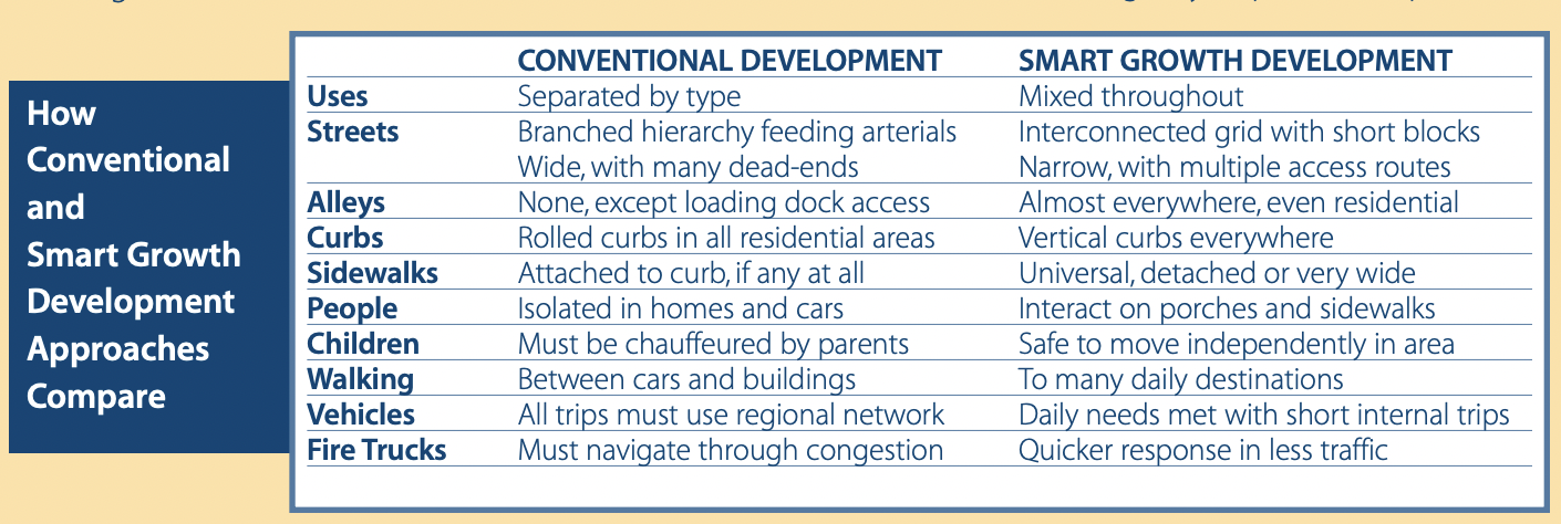
Compared with pre-war designs, conventional suburban streets have the following characteristics:
- Wider pavement widths.
- Longer blocks.
- A “super-grid” pattern with local streets within the superblocks.
- Gently curving streets.
- Numerous cul-de-sacs.
- Rolled curbs with a much wider radius at corners.
- Infrequent or inadequate sidewalks.
- Little attention to non-motorized travel.
This street pattern fit well with land use patterns where single-family residential, apartments, employment and shopping uses were all segregated from each other in large, single-use districts connected with a near-expressway super-grid. However, as car ownership, vehicle trips, and miles traveled have all increased, this development pattern has caused serious problems.
Designing streets for everybody
Funneling large volumes of cars through a limited number of intersections is less efficient than dispersing those vehicles over a larger network with numerous intersections. The result can be seen in many post-World War II communities today – long delays and congestion on collector and arterial roadways.
Longer travel distances and few connections between destinations also mean that routine trips, like going to school or picking up a loaf of bread, require a vehicle trip, thus further compounding the problem.
This street pattern has a direct impact on emergency response. Congested streets and limited connections and access points can significantly increase response times. Wide, high-speed streets – particularly those in residential neighborhoods or near schools and shopping areas – also increase the risk of accidents with other vehicles and pedestrians.
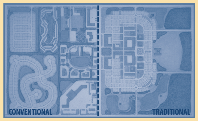
Two development and travel patterns
The left side of the illustration shows a conventional neighborhood, with each type of use – single-family, multi-family, office, commercial and public – segregated into single-use tracts. The street connections collect ever higher levels of traffic in a hierarchy that eventually dumps vehicles onto the regional supergrid of arterial streets. Any trip between destinations of different land uses – no matter how close they are to each other – must use these arterials.
By comparison, the traditional neighborhood designed with smart growth principles (on the right) contains a balanced mix of uses, so that many day-to-day travel needs of area residents can be met locally. These trips can be made on foot, but if a car is used require only a short drive inside the neighborhood, without impacting the arterial network.
Forcing all vehicle travel out onto the regional arterial network makes traffic congestion inevitable. This congestion – unnecessary in a smart growth community – means delays for all travel and a navigation nightmare for emergency responders.
Traffic calming measures can restore some balance to non-motorized travel, but it can be difficult to do so without affecting emergency response times. If designed properly, streets can meet the multiple needs of residents and cars, while also providing the environment that emergency responders require.
Changing Approach to Design
A sweeping change in approach is required when smart streets are designed. At the outset, it must be understood that the “street” is the entire space between buildings on opposing sides of the street, not just the curb-to-curb pavement section.
This larger space must be designed to meet parallel objectives that place safety and convenience for pedestrians and bicyclists on a par with motorized vehicle travel. The street must also provide parking, and be visually appealing.
The primary factor that determines the character of a particular street is its function in the neighborhood, not the volume of car traffic that a computer model predicts it must accommodate. This is a philosophical shift away from what has been standard practice in traffic engineering for the last few decades.
For example, if you want to create a “main street” type neighborhood commercial center, do not design the street for high volumes of traffic – no matter what the computer simulation says. Six lanes of fast, noisy cars will be hazardous to pedestrians, and destroy the quiet environment that encourages people to stroll around a neighborhood center.
A well-designed street in a neighborhood center should be two lanes – and never more than four – with curbside parking, generous sidewalks and design features that strictly limit vehicle speed. Simply put, it is a small-scale boulevard, not an expressway.
Providing bicycle lanes along all arterial streets is an important consideration, and can greatly benefit emergency response. The bike lane becomes available for cars pulling to the right to clear the through lane for emergency vehicles. With curb-to-curb vehicle lanes, it is more difficult for cars to pull out of the way.
Slowing vehicle speeds is important, since the higher densities typical with smart growth mean there is so much more non-vehicular activity on the streets. A driver in a conventional street environment “owns” the road, except for a few crosswalks at selected corners. The driver’s attention is focused only on his own actions and those of other drivers.
On a smart-growth street, the driver must slow down and be alert for:
- Pedestrians in crosswalks.
- Pedestrians crossing away from crosswalks.
- Bicyclists entering, crossing, and riding along the street.
- Cars entering and leaving curbside parking spaces.
- More frequent intersections and crosswalks.
- Curb bulbs, pedestrian refuges, and other safety features not in conventional streets.
The kinds of smart-growth design concepts described in this fact sheet will let the street engineer get it right initially, so that expensive, controversial and time-consuming traffic calming projects are not needed later to correct poor design.
Signs of smart growth streets
The simplest way to learn what smart-growth streets are like is to look at pre-World War II neighborhoods in any city in America. There you will see most of these characteristics:
- Distinction between streets for regional travel and local access.
- Reduced pavement widths, as narrow as 26 feet for two-way residential streets.
- Rectangular blocks, no longer than 500 or 600 feet, with pedestrian passages if longer.
- Alleys in most settings, residential and neighborhood commercial.
- Streets that favor straight lines, curving only when topography dictates.
- Termination points at prominent landmarks, such as a park, church, city hall or clock tower.
- Bike lanes or bike paths connecting key destinations and districts.
- Medians, generally raised and landscaped, on “main streets” and arterials.
- Sidewalks everywhere, with planting strips in residential areas, concrete to the curb in commercial areas.
- Heavy use of pedestrian-friendly devices like curb bulbs and pedestrian refuges.
- 6- to 8-inch vertical curbs.
- Curbside parking virtually everywhere.
Why emergency responders should care
Regional benefits: Employed on a regional basis, smart growth land-use patterns and street design will reduce arterial congestion because more daily trips will be made internally in neighborhoods without venturing out onto the regional arterial network. This reduced congestion benefits emergency responders because fire, police and ambulance vehicles will encounter fewer cars on primary response routes; and private vehicles will be able to use bike lanes to move out of the way.
Local advantages: Employed in select districts, smart growth land-use patterns and street design will improve fire, police and ambulance access because they are provided many different routes to an emergency scene. This reduces the need for excess pavement width to allow emergency vehicles to pass by vehicles that are already deployed at a scene. Those later arrivals can come down the street from the other direction, or go to the rear of the scene via the alley. Both of these approach strategies are impossible with conventional development that favors dead-end streets and lack alleys.
Who wins with good street design?
Emergency Responders – who see less congestion, improved access and fewer barriers.
Residents – who will enjoy a safer, quieter and more attractive public realm.
Store Owners – with more shoppers and sales generated by increased pedestrian activity.
Property Owners – who will see significant increases in property values.
Traffic Engineers – who will be lauded for understanding current practices in street design.
Elected Officials – who will be lauded for designing slower, safer, quieter streets.
Drivers – whose trips will be safer and less stressful.
Pedestrians – who will be healthier, and have the status on the street that they deserve.
Bicyclists – who will benefit from dedicated bike facilities and an ethic of sharing street space.